View from the Bridge
A sea-level navigator's assessment of Hormuz, Kharg and the geometry of coercion: The lanes, the islands, the upstream node, and the illusion of space.

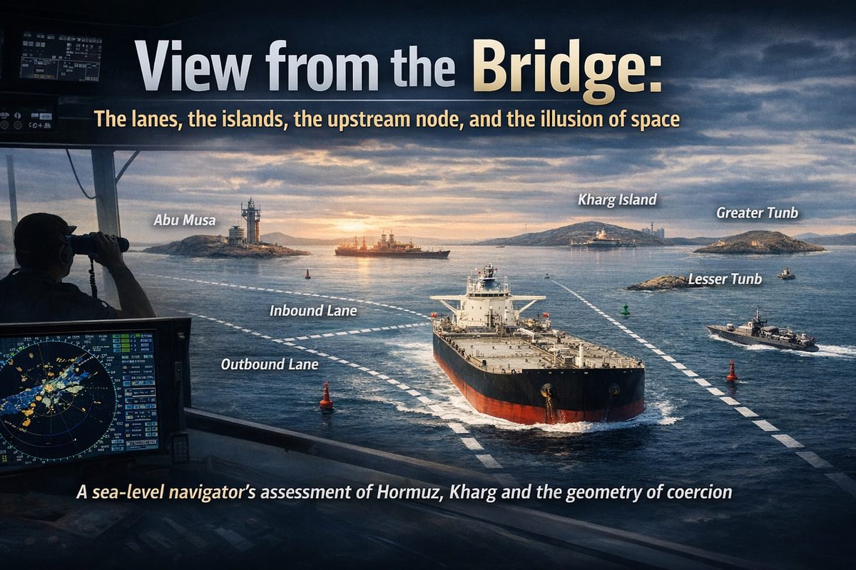
Most commentary treats the Strait of Hormuz as a broad strategic chokepoint. The real drama lies in a much smaller space: two narrow shipping lanes, the disputed arc of Abu Musa and the Tunbs, and an upstream oil system centred on Kharg Island — now an island under American bombs and the object of American ground-force planning.
This essay began as a navigator’s argument about confinement. Events have since converted it into a navigator’s warning about what happens when the logic of confinement is ignored by those planning to put troops ashore.
Most writing on the Hormuz crisis is from a distance — barrels per day, LNG flows, insurance rates, escalation risks, the danger of closure. That distance can distort operational solutions. This essay looks at the space from sea level.
To put it in context, let me take you to another maritime hotspot. I navigated the Gulf of Aden from November 2008 to January 2009, in command of INS Mysore, providing piracy protection to merchant traffic along what later became the Internationally Recommended Transit Corridor. Earlier, in 2005–06, I had taken INS Ranjit into Southeast Asian waters — through the Strait of Malacca and a brief foray into the South China Sea as part of a carrier battle group in July 2005, and on to Chittagong and Yangon in December 2005. These experiences shape how I think about chokepoints and restricted waters. The view from a satellite or a chart is one thing; the view from a Ship’s Bridge at night, with water under the keel and soundings (depth) on a navigation chart, is quite another.
On the map, the Strait of Hormuz looks broad enough to absorb pressure. On a navigator’s screen, it looks very different: a narrow, managed corridor where very large ships are funnelled into predictable tracks, overlooked by disputed islands, nearby coasts and fixed infrastructure whose geography matters as much as fleets or headlines. That microscope view has never mattered more than it does in the last week of March 2026, when two Marine Expeditionary Units (MEUs) are moving toward the Gulf and the Pentagon is preparing what it describes as weeks of ground operations.
The Illusion of Space
The Strait is often described as about 33 kilometres wide at its narrowest point. That is true, but also misleading. What matters to navigation is not the full width of water between Iran and Oman. What matters is the Traffic Separation Scheme (TSS): two main traffic lanes, one inbound and one outbound, each roughly two nautical miles (about three kilometres) wide, separated by a two-nautical-mile buffer. In practical terms, what appears on a political map as open sea becomes, for deep-draught commercial shipping, a narrow maritime road.
A Very Large Crude Carrier (VLCC) or Liquified Natural Gas (LNG) carrier does not improvise in such water. It follows the charted route, the TSS, draught constraints, navigational warnings, and the commercial risk calculus imposed by owners, insurers and charterers. That predictability is the source of the Strait’s vulnerability — not because every mile must be physically dominated, but because ships moving through a narrow and managed corridor are easier to monitor, threaten, delay, divert or psychologically unsettle than ships dispersed across broad ocean space.
Hormuz is not best understood as a wide body of water that might one day be shut. It is better understood as a constrained routing system that is already narrow, already managed, and already predictable. Think of it less as open sea and more as a dual expressway without a separating shoulder.
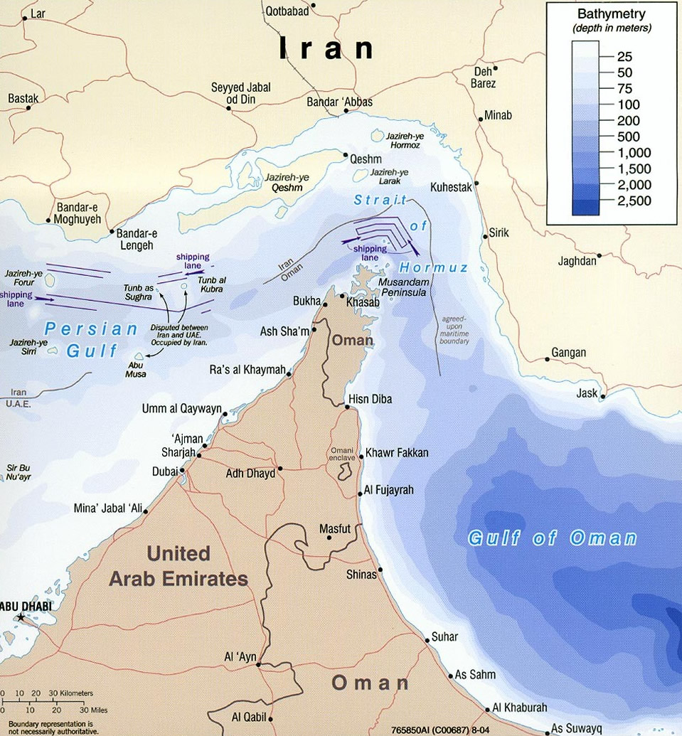
This is why so much loose talk about closure obscures more than it reveals. In such a confined and organised passage, a complete physical blockade is not necessary. Disruption, intimidation and commercial paralysis can begin well before that point. Iran has demonstrated this precisely: as of late March 2026, Iran is blocking Gulf countries from exporting their oil while allowing tankers picking up Iranian crude to pass freely — a surgically asymmetric use of the corridor, not a blanket closure. The distinction, which most commentary missed, is the one that matters operationally.
The Three Islands Not Scenery
Abu Musa, Greater Tunbin, and Lesser Tunb are often mentioned in passing, usually as the context of a sovereignty dispute between Iran and the UAE. In the present crisis, they should be read less as diplomatic footnotes and more as tactical ground — a point confirmed by their now appearing explicitly on the American target list.
Their modern significance dates from Britain’s withdrawal east of Suez. In November 1971, just before the formation of the UAE, Iran seized Greater and Lesser Tunb and established itself on Abu Musa under a separate arrangement involving Sharjah. Iran has retained effective control ever since. That history matters not merely for legal reasons. Once those islands are plotted against Iran’s coast to the north and Omani territory to the south, the geometry of the eastern mouth of Hormuz begins to sharpen. Radar lines, surveillance arcs, missile coverage, fast-attack craft operating areas, helicopter staging and mining approaches all overlap with the shipping lanes themselves.
The islands matter because they sit next to a corridor in which merchant traffic is channelled, not diffuse. Internal U.S. planning documents now reportedly include seizure of Abu Musa and the Tunbs among the options for a decisive blow — confirming that the geographic logic described here is also the logic driving operational planning in the Pentagon.
Kharg and Hormuz are One Machine
In mid-March 2026, Kharg Island ceased to be a hypothetical vulnerability and became a live target. U.S. forces struck more than 90 Iranian military objectives on the island, including air-defence, naval and mine-related facilities, while pointedly avoiding the main oil-loading infrastructure. Initial Iranian statements and third-party monitoring suggest that crude loading continued in the days after the strikes, with tankers still observed alongside Kharg’s jetties.
Kharg is not merely another Iranian oil terminal. It handles roughly 90 percent of Iran’s crude exports — the final concentration point of a system in which pipelines from Iran’s major onshore fields all terminate at the island before oil moves to sea. Because most of Iran’s coastline is too shallow for supertankers, there is no practical alternative. Trump himself summarised the geometry without intending to: ‘We’ve taken out everything but the pipes. We left the pipes because to rebuild the pipes would take years for them.’
Hormuz is the downstream release valve through which not just Iranian barrels, but Gulf energy more broadly, must pass into the wider world. Seen separately, Kharg and Hormuz are two stories: one about a concentrated export hub, the other about a narrow maritime funnel. Seen properly, after the March strikes, they are one machine under pressure — an upstream node that can be attacked without yet being destroyed, and a downstream corridor whose lanes can be psychologically emptied without being physically closed.
The present crisis is therefore not only a question of whether Hormuz will be blocked, but how a small number of fixed nodes and constrained routes can be pressured, degraded or made commercially unusable — and what it costs to hold one of those nodes once you have seized it.
The MAGTF Question and the Confinement Paradox
The deployment of the 31st MEU aboard USS Tripoli, accompanied by USS New Orleans and USS San Diego, with the 11th MEU and elements of the 82nd Airborne Division following, has generated considerable tactical commentary. Most of it focuses on the seizure problem. Very little of it addresses the transit problem, where the navigator’s perspective becomes essential.
The MEU carries infantry, attack helicopters, MV-22 Ospreys, F-35B stealth fighters, amphibious landing craft and its own logistics. It is purpose-built for forcible entry. The vertical envelopment option — stand-off assault by MV-22 and helicopter, bypassing the need to transit the Strait with the amphibious hull — is tactically sound and clearly part of the planning, with military analysts describing a low-altitude insertion designed to place troops on the island before Iran can respond effectively, using Kharg’s own oil infrastructure as fire suppression: Iran cannot shoot into its own tank farm.
But the stand-off option requires a secure forward mounting base inside the Gulf — and the Gulf is not secure. Both Kuwait and Bahrain, the logical mounting bases for an Osprey assault, are currently under Iranian missile and drone attack. The transit of the Strait itself, if the amphibious ships are required to proceed to launch position, compresses those ships into the same two-nautical-mile lane described at the outset of this essay — against an adversary who reportedly could have seeded it with mines since the war began and is known to operate fast-attack and underwater craft .
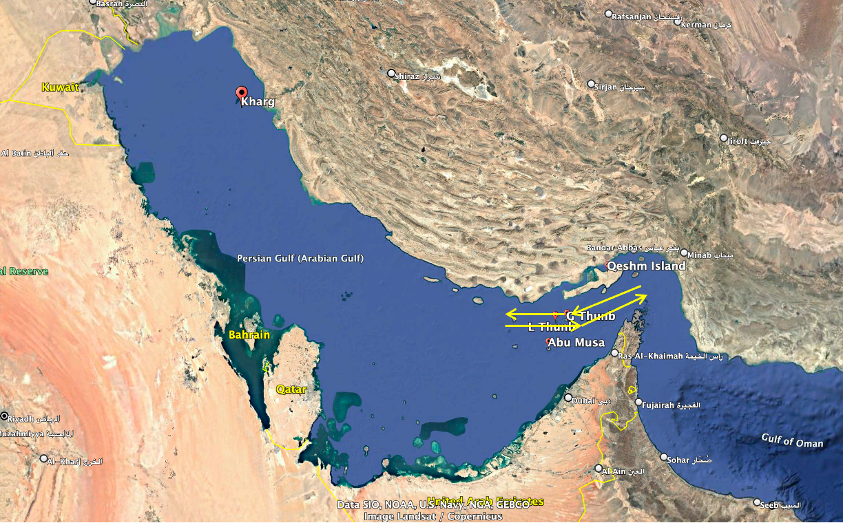
Here is the confinement paradox in its starkest form. The Strait’s geometry, which this essay began by describing as the source of commercial shipping’s vulnerability, is identically the source of an amphibious task group’s vulnerability. The same predictable corridor that makes tankers easy to threaten makes assault ships easy to target. Former NATO Supreme Commander Admiral Stavridis identified it precisely: before any ground operation, the ships would have to pass through the Strait, contending with Iranian drones, ballistic missiles and mines, and once in position off Kharg, the Marines would need ironclad air and sea superiority over at least 100 miles around the island.
To a reader in Bengaluru: the distance from the Strait’s eastern entrance to Kharg Island is approximately that from here to Pune (not as shown in the masthead graphic) — roughly 700 kilometres of enclosed, mine-threatened water that every resupply ship must traverse. At the far end of that journey, the island sits 23 kilometres from the Iranian coast — closer than the city’s airport to the Hebbal flyover.
There is no hinterland. The garrison that holds Kharg is, at all times, within artillery range of the country it has just seized territory from.
The Follow-on Force Problem
The seizure of Kharg Island is probably militarily achievable. Two MEUs could do it. The harder question — the one that receives far less attention — is what comes next. And here, the gap between the force being sent and the force that would actually be required is not a matter of degree. It is a categorical mismatch.
A MEU sustains itself from its ships for 15 to 30 days. It is a raid force: go ashore, accomplish the mission, return to the ships. The 82nd Airborne deploys without armoured vehicles, carries limited supplies, and is designed for 72 hours of independent operations before heavier forces must arrive. Neither instrument is a garrison. Neither was designed to hold a five-mile island 24 kilometres from a hostile coast under persistent fires from the mainland.
What a genuine garrison of Kharg Island would require has been catalogued with some precision by analysts: mine countermeasures ships to clear the approaches; air defence batteries capable of intercepting MLRS and cruise missile fire from the mainland; armoured vehicles to operate on terrain that Iran is reportedly lacing with anti-personnel and anti-armour mines; combat engineers to maintain oil infrastructure under wartime conditions; a sustainment brigade to keep the garrison supplied across 350 miles of contested water; and a rotation force of several thousand soldiers with armoured vehicles to relieve the Marines within weeks. None of those elements has been ordered to deploy. The gap is visible in every category.
There is one coherent bridging concept in the planning: repair the airstrip, fly in C-130 sustainment, use the 82nd to hold while heavier forces assemble. But every C-130 on final approach to a strip 24 kilometres from the Iranian coast is inside MLRS range. Every fuel bowser on the apron is a target. And the sea logistics tail — bulk water, ammunition, fuel, medical — still requires maritime resupply through 300 miles of the Gulf that Iran retains the capacity to attrit continuously.
The Platoon House Warning
This is where the Afghan comparison earns its place — not as a rhetorical flourish but as a structural analogy that maps almost exactly onto the Kharg problem.
In the summer of 2006, a small British task force in Helmand Province found itself stretched across a series of fortified district centres — platoon houses — in Sangin, Musa Qala and Now Zad. The origin of the commitment was political, not military: the provincial governor insisted that ISAF troops garrison towns under Taliban threat, and the task force commander could not refuse the political imperative, even though he had only one deployable infantry battalion. The garrisons came under immediate and sustained siege. Resupply required night-only helicopter operations. The reach of each garrison never extended beyond a few kilometres from the wire. By the time one British platoon leader finished his tour, he wrote that Sangin was no safer than when he found it — in fact, more dangerous and getting worse. The Afghan governor eventually asked the British to stop referring to Sangin as a district, when all they occupied was a base.
You can seize and hold the island. You cannot, from the island, reopen the Strait. Iran can maintain the Hormuz closure regardless of who controls Kharg — because the closure mechanism is mines, drones, harassment and commercial paralysis in the lanes, not a flag on a piece of rock 300 miles away.
The structural parallel to Kharg is uncomfortable in its precision. The platoon house garrison held the building. The Taliban held the surrounding terrain and kept up the kinetic fire. The garrison could not convert physical presence into strategic effect. The cost accumulated until the political will to continue broke before the Taliban’s did. On Kharg, the building is an oil export terminal. The terrain is the Iranian mainland and the waters between. Iran does not need to retake the island. It needs only to sustain sufficient attrition against the garrison and its logistics tail — which it can do from 24 kilometres away, indefinitely — until Washington decides the cost exceeds the leverage.
The one difference from Helmand that makes the Kharg problem worse, not better, is that the Taliban could not sink the helicopters. They could shoot at them, and eventually forced night-only operations, but the air bridge held. Iran can threaten the sea bridge to Kharg with missiles, drones, mines and fast-attack craft across 300 miles of enclosed, mine-contaminated Gulf. And the naval assets consumed in protecting that logistics line are the same assets needed to convoy oil tankers through the Strait — the mission that supposedly justifies the entire operation.
Closure Wrong Mental Model — for a New Reason
When this essay was first written, the argument against the closure mental model was primarily commercial: a strait need not be sealed to produce the economic effect of closure. Mines, drone attacks, missile threats, harassment by small craft, boarding risks, temporary route suspensions and higher war-risk premiums can begin to empty lanes well before the passage is formally blocked.
That argument still holds. But there is now a second reason to reject the closure binary — a military one. The debate over seizing Kharg has imported the same binary thinking into operational planning: take the island or don’t, bankrupt Iran or don’t, end the war or don’t. It misses the third outcome, which is the most likely: take the island, find that Iran has retained the ability to keep the Strait effectively closed regardless, and discover that you are now defending a small piece of rock at enormous cost with no exit that does not look like withdrawal under fire.
A Chatham House analyst has articulated the adversary’s calculus with precision: Iran would rather lose Kharg Island and retain the ability to keep the Strait effectively closed than enter negotiations over it. The Iranian leadership understands that Hormuz is its strongest leverage point. Kharg is the asset; Hormuz is the weapon. Seizing the asset does not disarm the weapon.
The more useful strategic question — the one this essay has been building toward through other publications that lay the groundwork — remains: how much disruption can be imposed on a narrow, rule-bound maritime corridor before the world experiences the effects of closure without its formal declaration? The March strikes on Kharg’s military sites have sharpened that question without answering it. A ground assault on the island would not answer it either. It would simply add a new variable — garrisoned American troops under persistent fire — to a system whose underlying geometry has not changed.
The Sharper Conclusion
The current Hormuz crisis is not just a macro-energy story or just a story about navigational confinement, though it is both. It is also a story about what happens when the logic of confinement — so clear from a bridge at night, with soundings on the chart and water under the keel — is abstracted away in policy discussions until it reappears as a tactical surprise.
The lanes are still two nautical miles wide. The islands are still tactical ground, and now explicitly so. Kharg and the Strait are still one machine, now under more direct pressure than at any point since the Iran-Iraq War. The MAGTF approaching through the Strait faces the same constrained routing problem that every commercial master faces transiting the TSS — only with an adversary who is actively mining and attacking the passage rather than merely monitoring it.
And if troops go ashore on Kharg, they will face a version of the platoon house problem at maritime scale: a garrison that can be supplied only through contested water, on an island that is visible and targetable from the mainland, in a position whose strategic logic depends entirely on whether Iran can be coerced into reopening a strait it has no reason to reopen simply because someone is standing on its oil terminal.
The overheated language of closure gives way, on close inspection, to a more exact and more serious question — made sharper by every development of the past three weeks, and not yet answered by any of them: how much disruption can be imposed on a narrow, rule-bound maritime corridor before the world experiences the effect of closure without its formal declaration? Putting boots on Kharg does not resolve that question. It adds American lives to it.
Substack post on 30 March 2026